Was just checking Google Earth after Mr. Wong was mentioning it to me yesterday. Yeah, we’re that geeky but isn’t it the in-thing to be geeky? Haha! Anyway, we were having a discussion on how cool it was but also that the pictures are a few years old. Seems like quite a fair bit of pictures available are old.
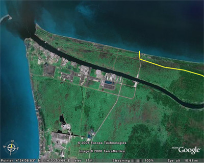
I took a closer look at Miri and Kuching. Here is a snapshot of the Baram River at Kuala Baram.

Makes you wonder what all those black stuff are. *Shudder* The Miri Port is there as well as the heavy industries. There’s definitely something not write about that water when you see that further upstream, the water is a very nice deep blue or pale blue.
No wonder the newspapers were having a field day a few years ago about how badly polluted the rivers are in Sarawak. Even the Kuching River is black but because the pictures are old, I can’t tell whether the river is better now. It’s still the old picture because there’s still a lot of silt in the River but that should have changed with the new weir at Sungai Sarawak Kiri.
So, errm… parents, relatives, friends and readers, if you end up seeing my face in the papers, well, errm… They wouldn’t shoot the messenger rite? O_o. Oh btw, Dad, you might want to try this program out. It’s very nifty and you can find people’s houses there. Haha!
Wena,
you’ve been tagged!
that does look nasty.